After touring Cinnamon Bay, we continued along North Shore Road, stopping to take in the iconic view above Trunk Bay, and on into Cruz Bay.
Our first stop was the visitor center. Sean and I stamped our National Park passports, and we all did some shopping. I had a long chat with a friendly and knowledgeable volunteer, Sherine, who made sure I had every pamphlet and map available. We inquired about the ranger-led Reef Bay hike, but we had to purchase tickets at the Friends of the Park shop down the street. The staff also recommended a place to get lunch.
Virgin Islands National Park is beautiful, unquestionably so. It is also deeply complex, defying expectations of what a National Park is, particularly in such a singular place. It has certainly gotten under my skin, and I’ve been thinking a lot about how to write about it.
Since we’ve been back, I’ve told friends and colleagues that the park is a great balance of spectacular scenery, abundant wildlife, and fascinating history. The comparison to another island park dear to my heart, Isle Royale, is apt. That park too has those three elements, but at Virgin Islands they are writ gigantic. So much scenery! So much wildlife! So much history!
Virgin Islands National Park could be the standard for the evolving mission of the Park Service over the past forty years. Particularly in the eastern United States where pristine landscapes are hard to find, sites that blend cultural and historic landscapes have become the focus of more recently established parks. The site that springs immediately to mind (at the National Park level, as opposed to other NPS holdings)is Cuyahoga Valley National Park in Ohio, which protects natural areas, many extensively restored, along with the cultural history of the Ohio & Erie Canal Towpath and the various historical communities in the valley.
After breakfast, we decided the best thing to do on our first day was to orient ourselves a bit more to the island and the park by driving back to Cruz Bay along North Shore Road, this time able to see all the vistas that had been hidden by darkness. In Cruz Bay, we could stop in at the visitor center and learn about any activities happening in the park during our time on the island.
We climbed into the Jeep and headed out. Although it was easier to navigate the steep twists and turns by day, without headlights there was less warning about approaching cars around the blind curves.
When we reached Cinnamon Bay (see map), we decided to stop and explore the ruins of the estate’s sugar and bay rum factory, which was visible from the road. It was about 10:30 am, and the parking lot was bustling with families and couples headed to the beach. (Cinnamon Bay is also the location of the park’s only campground for tents, and we were very glad we’d opted for the seclusion of Concordia.)
Instead of heading to the water, we crossed the road to the ruins, where a wheelchair accessible boardwalk winds through a stand of bay rum trees. In 1903, the factory began processing the essential oil of the leaves into St. John Bay Rum cologne and lotion.
Greater Antillean Bullfinch, photographed from our eco-tent’s deck.
One of the most delightful aspects of staying in an eco-tent on a hillside in the middle of a dry tropical forest was the opportunity to be surrounded by wildlife. Nearly everything on the property except the roads and the main buildings is raised on boardwalks and platforms, allowing wildlife to move freely underneath or overhead. The fact that the southern part of the property, which abuts the National Park, is kept wild only enhances the connection with nature.
Green Iguana, photographed resting on a branch parallel to the walkway to our tent.
Although Wednesday had been a very long travel day, we all awoke Thursday morning, March 7, before the sun rose (about 6:30am). It was due less to the light beginning to filter into the eco-tent than to general excitement.
Phil is generally an early riser, so I suggested to him that the two of us go and check out the beach while the others were still waking up. He agreed, and we slipped into our bathing suits, grabbed our towels, and headed for the Concordia nature trail, which led (after about a 15-minute walk) into the National Park at Salt Pond Bay.
Tuesday, March 5, Bethany flew to Chicago in the worst March snowstorm the region had seen in years. Miraculously, she made it, and her flight landed safely and early at O’Hare. That evening, we hung out and ate pizza while Sean finished packing.
Next morning, it was off to O’Hare and our flight to Miami and then, Charlotte Amalie on St. Thomas. Phil and Adam were flying from Detroit through Atlanta to the island.
In 1917, the United States purchased the three islands of the Danish West Indies, St. Thomas, St. John, and St. Croix, in order to prevent German holdings in the Western Hemisphere should Denmark be conquered in the First World War. Virgin Islands National Park was established in 1956 after Laurance S. Rockefeller donated 5,000 acres on St. John for a park. Today the park boundary encompasses two-thirds of the twenty-square mile island, although because of private inholdings, the park service owns only about half of the acreage on the island.
Shortly after our trip to Olympic National Park in April 2012, I switched jobs, as Sean had earlier in the year. The life transitions ultimately meant no more park trips in 2012. But the time also afforded the opportunity to do some systematic thinking about how to proceed with this project. Over the summer, in lieu travelling, we began to reach out to friends who had expressed interest in the project and to ask them which parks, specifically, they were interested in. We received a wonderful range of responses and potentially some tantalizing mixes of people were various trips to work out.
Looking ahead in the summer of 2012, Sean was keen to visit a warm weather park in the winter. His previous firm had been very busy during tax season, so now he finally had a chance to escape the Chicago winter. That, plus specific, enthusiastic interest from several friends placed Virgin Islands at the top of the list.
Rising out of the Gabilan Mountains east of central California’s Salinas Valley, Pinnacles is the result of millions of years of erosion, faulting and tectonic plate movement. Within the park’s boundaries lie nearly 27,000 acres of diverse wild lands. Visitors delight in the beauty and variety of its spring wildflowers and more than 400 species of native bees. The Pinnacles rock formations are a popular destination to challenge technical and beginner climbers alike.
Designated as a national monument in 1908 by President Theodore Roosevelt, the park’s management will not change by the legislation. The Pinnacles National Park Act recognizes the broader significance of park resources, specifically the chaparral, grasslands, blue oak woodlands, and majestic valley oak savanna ecosystems of the area, the area’s geomorphology, riparian watersheds, unique flora and fauna, and the ancestral and cultural history of native Americans, settlers and explorers.
In his engrossing Wilderness in National Parks: Playground or Preserve, John C. Miles, professor of environmental studies at Western Washington University, traces the history of wilderness protection in the parks from their earliest days to the book’s present, 2008.
The history of the National Parks and other protected lands in the United States is the story of continually evolving ideas about how and why natural and historical areas should be protected for the common good. At its noblest, it is an acknowledgement that the people, collectively, own and administer the wildest, most beautiful and most historically important areas in the nation. The hows and whys of acquiring and administering these places is intrinsically tied to the concept of land held for the common good.
Almost 150 years ago, on June 30, 1864, Abraham Lincoln signed a bill granting scenic Yosemite Valley to the state of California to be held in the public interest as a park (eventually the valley would return to federal control as part of Yosemite National Park). Eight years later, when Congress moved to protect the geothermal features around the headwaters of the Yellowstone River in a region that lay in Wyoming, Montana and Idaho territories, there was no state to give the park to, so by default it became a national park. The concept of the national park was born out of necessity.
Tomorrow I begin a new job at a conservation non-profit, an opportunity to blend my interest in and love of the natural world with my career in non-profit communications. In preparation, I read for the first time Aldo Leopold’s 1949 classic, A Sand County Almanac. (It’s a wonder that I hadn’t picked it up before.) Leopold, who worked for the forest service before becoming a professor at the University of Wisconsin-Madison, proposes a land ethic that recognizes man as part of a larger ecological community, rather than as master for whom nature is valued only in economic terms.
Lake Crescent in the northern Olympics formed when a glacier-carved valley, whose river drained into the Elwha River, was dammed by a natural landslide some 8,000 years ago. Although it has since been stocked with alien fish species, the lake’s Beardslee and Crescenti trout evolved over millennia into genetically distinct populations found nowhere else on earth.
Lake Crescent’s official depth is 624 feet, but there are parts that are almost certainly deeper than 1,000 feet.
Highway 101 follows the southern shore of the lake, which allowed us to stop for a brief visit.
After Ruby Beach, we continued northeast on 101 out of the park’s coastal section and up the Hoh River Valley, which has been heavily logged. We turned east on Upper Hoh Road, and the walls of the Hoh Valley grew steeper around us. Shortly after reentering the park’s main section, the forest got denser and more otherworldly. The road twisted and turned along the river to our right.
We stopped to have a look at one of the largest Sitka spruces in the United States: over 270 feet tall and over 500 years old.
Ruby Beach lies just south of the Hoh River’s outlet into the Pacific. We parked in the lot on the bluff above the beach and made our way down the switchback trail. The trail emerges along Cedar Creek, which is flanked by piles of driftlogs. Sea stacks rise from the beach at low tide. Although they are massive, they are dwarfed by Abbey Island (to the left in the images above and below).
Image: Sean M. Santos
Low tide was at 12:15pm, and we arrived at Ruby Beach at ten after, perfect timing. Immediately in front of us was an unbroken stretch of sand, but we were hoping to see sea stars and other tide pool life, so Sean and I walked off hand-in-hand toward some of the smaller sea stacks and large rocks to the south.
After leaving Beach 1, we continued north on 101 until we came to a pullout on the inland side. Near Beach 5 was a short side road that led to one of the world’s largest cedar trees, boasting a girth of 66 feet.
From Quinault Rain Forest, Highway 101 descends through the Quinault Indian Reservation to the lower Queets Valley, a section of the park added by the Truman administration. From there, the road turns abruptly north and follows the coast for eleven miles, past seven specific beaches that comprise the southernmost coastal area of Olympic National Park.
The three of us spent two fun days exploring Portland from Powell’s Books to the Hawthorne District to food cart pods. Saturday morning, April 28, we returned to Seattle via the Olympic Peninsula. We rose early to get a head start on the three hour drive to the first, and southernmost, section of the park areas we wanted to see: Lake Quinault and the Quinault Rain Forest.
We woke up early, dressed, picked up our rental car (which we got upgraded to a Prius), and started down I-5 toward Portland. Almost immediately, we noticed how verdant the landscape was, from vines growing from overpasses in downtown Seattle, to moss on cut logs on the back of a lumber truck.
In January, my cousin Kathrin visited Chicago. She is looking to move on from our native Michigan, and while Chicago is on her list of potentially livable cities, so are Seattle and Portland. Kathrin suggested that Sean and I travel with her to both cities at the end of April. She and Sean had been to Seattle, but not Portland. I had never been farther north on the West Coast than Napa Valley. Sean and I were game for the trip, and soon we had our dates set.
That there are three National Parks within two or three hours of Seattle was not at all lost on me. And once we decided to fly in and out of Seattle and drive a rental car to and from Portland, it became obvious that we should stop at Mount Rainier National Park on the way. Rainier seemed an easy choice because it’s between the two cities, not out on the peninsula like Olympic or two and a half hours northeast of Seattle (the opposite direction from Portland) like North Cascades.
The title of this blog is an adaptation of Theodore Roosevelt’s words upon seeing the Grand Canyon for the first time:
Leave it as it is. You can not improve on it. The ages have been at work on it, and man can only mar it. What you can do is to keep it for your children, your children’s children, and for all who come after you, as one of the great sights which every American if he can travel at all should see.
Roosevelt was talking about a great natural site before it would be protected. Already there were mining designs on sections of the canyon. Parts of it were no longer pristine wilderness, and they aren’t now, nor will be. Now, as then, there are parts of the park designated wilderness and others for heavy tourist use.
I have no illusion that the parks as my traveling companions and I will experience them are truly pristine (save for perhaps the remotest of the Alaska parks), but they are somewhere on a continuum between civilization and wilderness.
We’re rethinking Mount Rainier. While it is the most accessible, in some ways, during our trip to Portland and Seattle next month, it is also the least accessible in others. I had been prepared for there to still be a lot of snow on the ground, and that we’d essentially be driving into the park up to where the road is closed at Paradise to look at the scenery, etc. In my mind, I’d likened it to the trips to Park City we’d taken when I was younger. Snow? Mountains? No problem.
In digging further, though, apparently all vehicles entering the park are required to carry tire chains until May 1, a big problem with a rental car. The more I’ve thought about it, the more I think that it would be going to the park at about the least optimal time of year just to say we’d done it. Advice from a friend in Seattle had some impact on this thinking.
So, we’re going to a different park, which I think will be much more rewarding, and which won’t alter our larger travel plans at all:
Eight years ago this week I visited Badlands National Park in the middle of January with my friend, Lisa. It was an impromptu Martin Luther King weekend road trip inspired in part by an article in that week’s New York Times about Marta Becket and her Amargosa Opera House in Death Valley Junction, California. Lisa, who was also my supervisor, and I had been intrigued by the story of the aging dancer and the performances she gave at her inn in the Mohave Desert.
For an afternoon, we fantasized about the possibility of adding a few vacation days to the long weekend and making the 66-hour round trip drive.
After that idea was justifiably set aside, we still had the road trip bug. Both of us were going through hard break-ups at the time and we needed some space from an Ann Arbor winter with its North Sea skies. Also, we’d each be able to talk through our emotions with the only other person who was in a similar place at the moment. As the weekend approached, we decided to leave the destination unplanned, but to head south. If it came to it, we figured, we could always find a Holidome near Louisville and spend the weekend bathing our sorrows in a hot tub and alcohol.
We set off on Saturday morning in the Pam Dawber, Lisa’s Ford Taurus station wagon, heading west on I-94 and then south on I-69. As we drove, we monitored the weather. A snowstorm was moving through the lower Midwest, across our path to Kentucky. We began to second guess our southerly route, and as the junction with I-80 loomed ever closer after we crossed into Indiana, we knew we had to make a decision whether to avoid the storm.
The access road to the 49 Palms Canyon Trail is directly off of the Twentynine Palms Highway. It is one of a cluster of park features that are accessed from the north via special roads and entrance stations.
The trail leads into a steep canyon to the 49 Palms Oasis, a natural oasis caused by water seeping up through the earth creating habitat for native California fan palms and other plant life. The hike is a three-mile roundtrip with a vertical change of about 350 feet.
After our sunrise visit to Cholla Garden and Ocotillo Patch, we headed back up Pinto Basin Road through Wilson Canyon, leaving the Sonoran behind and climbing into the Mohave.
We pulled into White Tank Campground, trying to make our way slowly and quietly so as not to disturb the car campers. We parked at the trailhead for Arch Rock Nature Trail, a short, .3-mile trail through a spectacular jumble of formations.
Our alarms went off at 5:30am so that we could pull on clothes and hats and jackets (it was 46 degrees) for the 45-minute drive into the park to the Cholla Cactus Garden in Pinto Basin. Sunrise was at 6:48am, but we didn’t want to have to rush through the dark desert.
We turned off of Park Boulevard onto Pinto Basin Road, which was closed due to the wash out not much further than our destination. The road turned east, and we stopped at a pullout above Wilson Canyon as the first light hit the granite formations and flooded the sky beyond.
From the beginning, the framework for our quick trip to Joshua Tree had been to watch the sunset in the Mohave Desert and sunrise in the Sonoran. We finished our walk through Hidden Valley at about 4pm, so we had a couple of hours to drive out to our motel, check in, and drive to Keys View in the Little San Bernardino Mountains before the sun set at 6:21pm.
Back in Joshua Tree, we turned east onto the Twentynine Palms Highway. About ten minutes later, we pulled into the Harmony Motel on the western outskirts of Twentynine Palms, California.
The motel’s tiny office is filled with U2 memorabilia since the band stayed at the Harmony while they were working on their 1987 album, The Joshua Tree. The motel’s current owner is Ash Maharaj, originally from South Africa, who purchased the motel seven years ago. In February 2011, she completed the restoration of the Harmony’s original sign, and her stated intention is to restore the entire motel.
As she showed us to our room, she warned us to be sure and shut the door behind us right away because it opened literally into the desert.
Hidden valley lies near the heart of the Mohave Desert section of Joshua Tree National Park. If a visitor had only a couple hours to spend in the park, the mile-long nature trail here would be a great choice.
The small “valley” is actually an area virtually surrounded by the park’s famous granite formations. It had been used in the previous century as a natural holding pen for rustled cattle, but in the months before Joshua Tree National Monument was established in 1936, longtime area resident, Bill Keys, dynamited an access path into the valley.
After flying to Orange County on Wednesday, a four-plus hour flight after work, we crashed with Aunt Judy and Uncle Tom, who had taken me to my first National Park over nineteen years earlier.
The weather forecasts for earlier and later in the week at Joshua Tree had called for daytime highs of 95 degrees, but the two days we planned to be the desert saw forecasted highs in the mid-70s and lows in low-50s. Although intellectually we’d been prepared for cooler than expected temperatures, we were still surprised that we were to have the same weather in Joshua Tree as at Isle Royale. It was all the more unusual considering that many of the campgrounds at the park, closed throughout the summer because of soaring temperatures, had just reopened for the season a week earlier.
Almost as soon as we arrived home from Isle Royale in August, we had to begin thinking about Joshua Tree National Park, which straddles the Mohave and Sonoran Deserts in southern California. Sean and I were invited to my youngest cousin’s wedding in Orange County in early October. My aunt and uncle’s house was only a two and a half-hour drive from Twentynine Palms, the gateway to Joshua Tree.
Although the wedding festivities would happen over the weekend we decided to fly out to Orange County on Wednesday evening, so that we could spend Thursday afternoon through Friday morning at the park.
We lunched at the Greenstone Grill one last time. We’d had the same server all the times we’d been there. Her name was Katie, and although she’d worked on the north rim of the Grand Canyon last summer, she hailed from Ferndale, Michigan.
After lunch, we had some time for last-minute souvenir shopping while we waited to board the ferry. Adam struck up a conversation with Ranger Lauren in the visitor center. She explained how about forty of the park’s sixty-five summer staff were seasonal since the park shuts down between October and April, and that she’d essentially be laid off at the end of the season. She hoped, though, to return to Isle Royale next year. She also said that full-time, established rangers are able to move from park to park until they find the one they want to stay at.
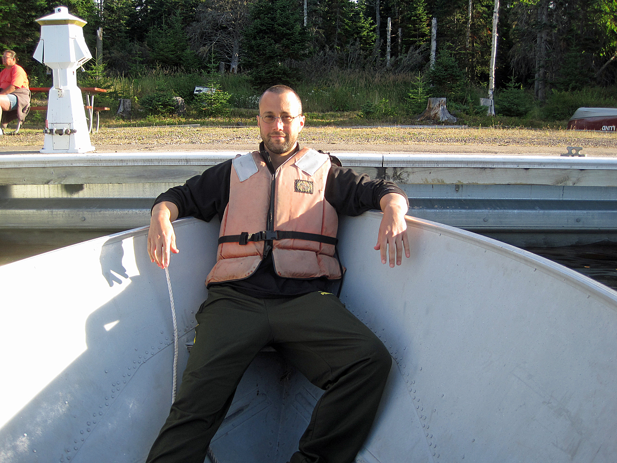
It was our final morning on Isle Royale. We’d be taking the ferry back to Copper Harbor at 2:45 that afternoon. First thing, Adam went down to the dock to see if they were letting people rent motorboats that day.
They were, so Adam and Phil made the arrangements while Sean and I got a breakfast table at the Grill. Afterward, we donned our life jackets and headed out into Rock Harbor, just before the Ranger III set sail.
As we neared Rock Harbor, we came across Smithwick Mine from the mid-1800s. Like Siskowit Mine, it’s a huge pit from which the miners extracted copper.
Scoville Point is the northeast tip of the peninsula ridge that houses Rock Harbor Lodge and visitor center. It is at the end of the 4.2-mile loop of Stoll Trail. We set out with little more than water for an afternoon hike there and back.
We reached Rock Harbor in the late afternoon, and to our relief, we had our pick of campsites. There were even shelters available. We looked at one, but decided that we simply preferred to sleep in our tents.
Thursday morning we woke up and took stock. In our original itinerary, tonight would have been when we camped at Daisy Farm, but we’d already been here two nights. Already the regret of not having made it to a campground on an interior lake, with an increased likelihood of seeing more wildlife, was hugely mitigated by having been at Daisy Farm the evening before for Candy Peterson’s talk.
We decided to begin the hike back to Rock Harbor where, Friday night, we had a room reserved at the lodge. Our goal for Thursday, however, was Three Mile. We hoped to get the same lovely, harbor-side campsite we’d had Monday night, or at least the one adjacent.
There was only a sprinkle of rain overnight, enough to make the rain cover useful, but by morning the sky was clear.
We breakfasted on strong coffee and dehydrated eggs, which were not my particular favorite. Phil was still feeling poorly, so he decided that he wouldn’t be joining us on our day hike up Mount Ojibway, at 1,133 feet, the highest point on the northeast side of the island.
We arrived at Daisy Farm early in the afternoon, so we had our pick of camp sites. We chose a lovely secluded spot in the forest and began to set up camp. Earlier on the trail, when we decided to stop at Daisy Farm, Adam and I toyed with the idea of doing the trail to Mount Ojibway as a day hike later in the afternoon. Once we began to unpack, however, we decided simply to stay put. In fact, we unanimously decided that we’d stay two nights at Daisy Farm to give Phil time to feel better. The forecast called for a chance of rain that night, so we pulled out the rain flies for our tents.
We woke late at Three Mile, sore from the unexpectedly long hike the day before, but in good spirits. Adam and Phil filtered water and started breakfast, while I tended to my blisters and Sean tidied camp. The weather was gorgeous, sunny with a breeze off the water. We were able to look about us and see just how lovely our campsite was.
Crossing the Greenstone Ridge, we set off on the Lane Cove Trail, glad to be headed downhill, and about two thirds of the way through our hike for the day. The north side of the ridge is much steeper than the south side, and we were rewarded with a lovely view out into Lake Superior to the north. The trail descended in a series of steep switchbacks through a forest dominated by tall birches. Everything felt more lush, and somehow wilder, on this side. (more…)
We dropped off a pair of daypacks with clean clothes at the lodge to be held until we came back for our final night. Then we lunched at the Greenstone Grill before heading out toward Lane Cove Campground.
We had set our alarms for 6:30am Monday morning, but we were all awake before that, particularly early riser, Phil, who had scouted out a source of coffee before the rest of us were out of bed.
Sean at Michigan Department of Transportation Baraga Cliff Roadside Park Honoring Peter R. Kamarainen
Adam and Phil arrived Saturday evening from Detroit. Sean and Phil poured a round of drinks (Moscow Mules and rye on the rocks), and we set to work over the topographical map of northeastern Isle Royale. We hit upon an ambitious but achievable hiking route:
Day One: Rock Harbor to Lane Cove, 6.9 miles
Day Two: Lane Cove to East Chickenbone Lake, 10.9 miles
Day Three: East Chickenbone to Lake Richie, 5 miles
Day Four: Lake Richie to Daisy Farm, 5.8 miles
Day Five: Daisy Farm to Rock Harbor, 7.1 miles
Afterward, we sorted meals, took a clipper to my longish hair, and went to bed.
Unique among the national parks, the mere facts of Isle Royale create an evocative and compelling portrait:
Forty-five miles long, it is the largest island in the largest freshwater lake (by surface area) on earth. Its backbone, the Greenstone Ridge, was formed by the largest single lava flow on the planet, exposed by the glacier that melted to form Lake Superior.
With 16,000 annual visitors, the sixty-one year-old national park is the least-visited in the contiguous United States, and the fourth-least visited in the entire system. The only parks that see fewer annual visitors lie above the Arctic Circle or on American Samoa. An oft-quoted figure is that fewer people visit Isle Royale in an entire year than visit Yosemite or Grand Canyon in a day. It is only accessible via ferry or sea plane. It shuts down completely between October and April.
Designated a United Nations Biosphere Reserve, ninety-eight percent of the park is wilderness area.
Famous for its moose (which swam to Isle Royale from the mainland in the early years of the twentieth century) and for its wolves (which crossed an ice bridge from Ontario in the late 1940s), it boasts only a handful of mammal species: snowshoe hares, red squirrels, river otters, beavers, deer mice, bats, foxes. It is either inhospitable or inaccessible to deer, caribou, rats, and bears.
As a native Michigander, I felt that Isle Royale was the ideal park to launch this ambitious project. I spent six days in the park with my partner, Sean, and buddies, Adam and Phil.
This is the first in a series of posts about the trip.
Between finalizing reservations, assembling gear in earnest, and thinking on a hiking itinerary, I’m getting rather excited to visit Isle Royale. I’m nervous though, about several things. Utmost among them is concern that I won’t be able to sleep. I am a fetal-position sleeper, and sleeping pads and mummy sleeping bags are simply designed for people who sleep on their backs.
I’m also nervous, frankly, that the entire trip may be canceled. Now, if Republicans in the US House do force the Federal Government into default, there will likely be many more egregious results than the National Park System shutting down (like a halt in Social Security payments, for instance). But it would mean that we would not be able to go.
It lends a sense of fragility to the entire enterprise, belied by the sentiments in Ken Burns’ stellar documentary about the creation of the National Park System. Yes, these places are protected “in perpetuity” by a government and democracy that seem, sometimes, all too fragile themselves.
Yesterday, Sean and I spent some time at REI here in Chicago. We tried on several backpacks for next month’s Isle Royale excursion. Ultimately, we both went home with the same pack: the Osprey Atmos 65. Sean liked the way it fit and distributed weight. I very much liked the ventilation system between my back and the pack.
I also ordered our tent: the REI Camp Dome 2, which should arrive on Friday. We may try it out in Wisconsin in a few weeks in advance of going to the island.
This morning, we tried a freeze dried spinach omelette that we picked up while we were at the store. Not too bad.
I need to continue breaking in the boots that I got last month, also at REI. I went with the Merrell Phase Peak waterproof boots. I loved the way they fit and gripped.


